Kiwi 📷 Molly Johnson
Rohe
Our area
Our taonga is your taonga.
The Kaimai Mamaku ngahere, and their catchments, cover almost 300,000 hectares across Bay of Plenty and Waikato.
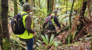
Our project area extends from the Waihou River to Tauranga Harbour, from Mokaihaha in the south to Karangahake Gorge in the north. The bush clad spine of the Kaimai range gives way to the misty plateaus and valleys of the northern Mamaku. An arm reaches eastwards toward the sea, embracing the hills of Ōtānewainuku and Otawa.
Our whenua is home to numerous iwi and hapū, almost 500,000 people and a diverse range of flora, fauna and funga.
Kaimai Mamaku is northernmost limit for popokatea/whitehead, silver beech, kamahi, and pink pine, and the southernmost limit for Coprosma dodonaefolia, towai and kauri. It is also home to native fish including long fin eels and giant kokopu, many of which depend on clear cool water and access to forested streams to feed and breed.
This transition zone is ecologically unique and gives rise to unusual combinations of animals and vegetation found nowhere else.
The Kaimai Mamaku ngahere plays a crucial role in stabilising fragile steep soils and regulating water flow. A dense, healthy forest cover lessens the risk of erosion and flooding - helping to keep our homes, farms, orchards, roads/bridges and harbours safe.
The forests also normalise sediment movement in waterways, ensuring that Tauranga Moana and the Firth of Thames/Tikapa Moana are not smothered in silt. Those harbours are the nurseries of the recreational fish that a third of New Zealanders enjoy catching.
Biodiversity
Click each picture to learn more about the taonga found in the Kaimai Mamaku.